A research team from the National Institute of Advanced Industrial Science and Technology (AIST) in Japan proposed a method to estimate shadow effects on vehicles equipped with integrated solar PV-based geographic information system (GIS) models and satellite data.
The estimates for the study area located in Fukushima City, Japan, were found to be in line with real-world vehicle-integrated photovoltaic (VIPV) measurements.
“While earlier studies often rely on local weather station data, we use satellite data from Himawari-8/9 to estimate solar irradiance along different geographic routes,” the research’s corresponding author, Pawita Bunme, told pv magazine, referring to the Japanese weather satellite operated by the Japan Meteorological Agency.
The GIS data was combined with high-resolution digital surface models (DSM) and digital terrain models (DTM) at 0.5-meter resolution, so the shadows from surrounding terrain and objects that affect solar radiation on vehicles could be accounted for.
“This allows us to assess solar irradiance during vehicle operation and helps plan routes to make the most efficient use of VIPV,” said Bunme.
The simulated direct and diffuse irradiation were used to calculate shading factors, and satellite-estimated irradiance data were applied to estimate total irradiance.
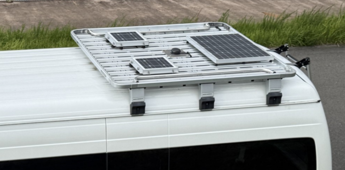
In the validation part of the study, estimated irradiance at five-minute intervals was compared with actual data collected along a specified route. For route measurements, a Toyota HiAce electric vehicle (EV) was equipped with solar PV modules to power a data logger and irradiance measurement sensors along with a GPS system and a speed meter to record its longitude and latitude at one-second intervals.
The vehicle, following a route typical of a community car service, made three trips per day along the same 25 km, from 10:00 to 16:00, with a slightly different 24-km route in winter to avoid slippery roads and accumulated snow. The data were collected continuously from May 2022 to January 2023, spanning eight months, according to the paper.
“The estimation results aligned with measured data on different operation dates and routes, with normalised mean absolute error (nMAE) of 3%-7% under clear-sky and 12%-13% under partly cloudy conditions,” said the scientists. Additional error metrics, including mean bias error (MBE) and root mean square error (RMSE), were calculated.
“The results highlight that shading is a significant factor in reducing solar irradiance during VIPV operation and should be incorporated into solar irradiance estimation methods,” they concluded.
They also noted limitations of the study with examples of future research topics, such as including estimates of the influence of cloud cover, using a variety of simulation tools and settings, and including simulated vehicle solar power generation data.
“For our next project, we aim to further improve the GIS-based solar irradiance estimation method for VIPV. This includes extending simulations to cover longer operation periods across more regions and validating results with actual measured data,” said Bunme.
Other projects underway include integrating PV with electric vehicles, demonstration in real-world applications, and investigations into the long-term reliability of VIPV systems.
Their findings can be found in “GIS-based solar irradiance estimation method in vehicle integrated photovoltaic,” which was recently published in Renewable Energy.
This content is protected by copyright and may not be reused. If you want to cooperate with us and would like to reuse some of our content, please contact: editors@pv-magazine.com.

By submitting this form you agree to pv magazine using your data for the purposes of publishing your comment.
Your personal data will only be disclosed or otherwise transmitted to third parties for the purposes of spam filtering or if this is necessary for technical maintenance of the website. Any other transfer to third parties will not take place unless this is justified on the basis of applicable data protection regulations or if pv magazine is legally obliged to do so.
You may revoke this consent at any time with effect for the future, in which case your personal data will be deleted immediately. Otherwise, your data will be deleted if pv magazine has processed your request or the purpose of data storage is fulfilled.
Further information on data privacy can be found in our Data Protection Policy.